


Geographic Ontology Driven Hierarchical Semantic of Remote Sensing Image
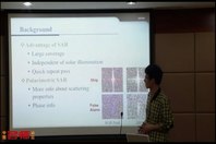
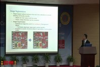
2012年遥感计算机视觉国际会议——Remote sensing study focuses on not only informationof image its own, but also geographic analysis based on these information. Unlike normal image, remote sensing image holds several special characteristics, which make impossible to create hierarchical semantic of remote sensing image only applying classic achievements on image hierarchical semantic. In this paper, we firstly indicate two characteristics of remote sensing image hierarchical semantic and provide processing from feature level to semantic level. Then depend on theories of geographic ontology, we design the framework of remote sensing image hierarchical semantic and test our framework through typical experiments. Overall, it proves that, compares with normal image hierarchical semantic, our remote sensing image hierarchical semantic owns ability to handle with the issue of both spatial, attribute, temporal semantic and logic reasoning. Result reveals that our idea holds much better in completeness and robustness driven by geographic ontology.
关键词: 计算机 遥感 视觉 图像 2012年遥感计算机视觉国际会议
主讲人:Xiran Zhou 机构:Wuhan University
时长:0:13:14 年代:2012年
热点排行
- 1 英语学习策略(1)
- 2 《图书馆与信息服务营销》先导片
- 3 古兽重现
- 4 Excel实战技巧精粹
- 5 在路上
- 6 恐龙绝灭与生态危机(1)
- 7 生物医学图像处理——绪言(1)
- 8 28号的青春
 京公网安备11010802020237号 |