


Mapping Burned Areas from Landsat TM Images:A Comparatives Study
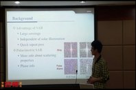
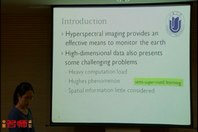
2012年遥感计算机视觉国际会议——2012年遥感计算机视觉国际会议——Remote sensing is a major source of mapping the burned area caused by forest fire. The focus in this application is to map a single class of interest, i.e. burned area. In this study, three different data combinations were classified using different classifiers and quantitatively compared. The adopted classifiers are the Support Vector Data Descriptor (SVDD), a one-class classifier, the Binary Support Vector Machines (SVMs) classifier and the traditional Maximum Likelihood classifier (ML). At first, the Principal Component Analysis (PCA) was applied to extract the best possible features form the original multispectral image (OMI) and calculated spectral indices (SI). Then the resulting subset of features was applied in the classification process. The comparative study has undertaken to find firstly, the best possible set of features (data combination) and secondly, an effective classifier to map the burned areas. Experimental results indicate that the best possible set of features was attained by data combination- III (i.e., combining SI and OMI information) in the study area. Furthermore, the results of the SVM showed the higher classification accuracies than the ML, but approximately equivalent to the SVDD, which only requires training samples from the class of interest. Experimental results also demonstrate that even though the SVDD for mapping the burned areas doesn’t showed the higher classification accuracy than the SVM, but it shows the suitability for the cases with few or poorly represented labeled samples available. The parameters should be further optimized through the use of intelligent training for improving the accuracy of the SVDD.
关键词: 计算机 遥感 视觉 卫星 2012年遥感计算机视觉国际会议
主讲人:Abeer Mazher 机构:Peking University
时长:0:18:04 年代:2012年
热点排行
- 1 英语学习策略(1)
- 2 《图书馆与信息服务营销》先导片
- 3 古兽重现
- 4 Excel实战技巧精粹
- 5 在路上
- 6 恐龙绝灭与生态危机(1)
- 7 生物医学图像处理——绪言(1)
- 8 28号的青春
 京公网安备11010802020237号 |